

Compass

Descrizione di Compass
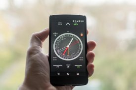
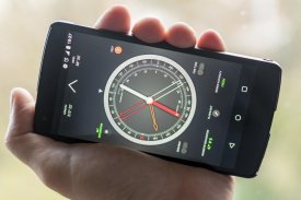
A compass is a navigation instrument with a free rotating needle that indicates the direction of magnetic north.
Most people know how to find the north using a compass. Few know how to use it as a navigation tool. The ability to navigate with a compass and a map is one of the most useful things to know while hiking. This compass app is not just a simple north direction indicator but is intended to be used as a real orientation tool for hiking activities.
Prerequisite: Your device must have an integrated compass sensor to function properly.
Highlights:
+ Orienting compass functions
+ Suitable for camping, hiking, and other outdoor activities
+ HD graphics
+ Quick step by step use guide
Features:
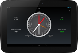
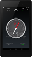
+ Rotating bezel
+ Rotating orienting arrow
+ Adjustable magnetic declination
+ Fine tune of the rotating bezel
+ Fine tune of the orienting arrow
+ Clinometer
+ Flashlight
Before you start using your compass
Each time you open the compass, shake your device a few times around its three axes in order to improve accuracy.
If your phone or tablet is protected by a magnetized cover, remove it before using the compass.
To rotate the compass bezel or orienting arrow, place two fingers on the screen at the same time and perform a rotation gesture.
Adjust the magnetic declination
1. Find the current magnetic declination for your location.
2. Push the Set Declination button.
3. Set the magnetic declination by turning the orienting arrow. You can fine tune the declination by activating the Fine Tune mode.
4. Push again the Set Declination button to block the orientation arrow.
Reset the magnetic declination
For a rapid magnetic declination reset, press and hold the Set Declination button.
Orient a map
1. Adjust the magnetic declination if necessary.
2. Rotate the bezel so that the north mark aligns with the index mark.
3. Place the device on the map so that its edge aligns with the map longitude lines.
4. Rotate the device and the map together until the magnetic needle aligns with the orientation arrow. Now your map is aligned with the geographical north.
Take a bearing from a map
1. Orient the map.
2. Place the device on the map so that its edge aligns with your current location and the location you wish to travel to.
3. Rotate the bezel until the orientation arrow aligns with the magnetic needle.
4. The direction of travel arrow on the compass gives you your direction of travel.
Find where you are on a map
1. Look around and select two distant objects that you can identify on your map.
2. Mark the selected objects on the map.
3. Orient the map.
4. Aim the direction of travel at the first object.
5. Rotate the bezel until the orientation arrow aligns with the magnetic needle.
6. Place the device on the map and draw a line along its edge through the mark of the first object.
7. Repeat from step 4 for the second object.
8. The intersection of the two obtained lines gives you your approximate position. If you repeat the process with a third object, the intersection of the three lines will result in a triangle. Your approximate position on the map is inside the triangle.
Measure the slope of the terrain
1. Rotate the bezel so that the east or west mark aligns with the index mark.
2. Place the device on the ground, aligned with the greatest slope.
3. Read the slope value shown by the clinometer needle on the inner scale of the compass.
La bussola è uno strumento di navigazione con un ago a rotazione libera che indica la direzione nord magnetico.
La maggior parte delle persone sanno come trovare il nord ausilio di una bussola. Pochi sanno come usarlo come strumento di navigazione. La possibilità di navigare con una bussola e una mappa è una delle cose più utili da sapere durante le escursioni. Questa bussola applicazione non è solo un semplice indicatore di direzione nord, ma è destinato ad essere utilizzato come uno strumento di orientamento vero e proprio per le attività di trekking.
Prerequisito: il dispositivo deve avere un sensore bussola integrata per funzionare correttamente.
Mette in risalto:
+ Orientare bussola funziona
+ Adatto a campeggio, trekking e altre attività all'aria aperta
+ grafica HD
+ Quick step by step guide uso
Caratteristiche:
+ Lunetta rotante
+ Rotazione orientando freccia
+ Declinazione magnetica regolabile
+ Sintonia fine della lunetta girevole
+ Sintonia fine della freccia di orientamento
+ Clinometer
+ torcia elettrica
Prima di iniziare a utilizzare la bussola
Ogni volta che si apre la bussola, scuotere il dispositivo un paio di volte in giro per i suoi tre assi, al fine di migliorare la precisione.
Se il tuo telefono o tablet è protetto da un coperchio magnetizzato, eliminarla prima di usare la bussola.
Per ruotare la ghiera bussola o freccia di orientamento, posizionare due dita sullo schermo contemporaneamente ed eseguire un'operazione di rotazione.
Regolare la declinazione magnetica
1. Trovare la declinazione magnetica attuale per il luogo.
2. Premere il pulsante Set Declinazione.
3. Impostare la declinazione magnetica ruotando la freccia di orientamento. È possibile ottimizzare la declinazione attivando la modalità Fine Tune.
4. Premere nuovamente il pulsante Set Declinazione per bloccare la freccia di orientamento.
Ripristinare la declinazione magnetica
Per un rapido ripristino magnetica declinazione, premere e tenere premuto il pulsante Set Declinazione.
Orientare una mappa
1. Regolare la declinazione magnetica, se necessario.
2. Ruotare il frontalino in modo che il segno nord si allinea con il contrassegno di indice.
3. Posizionare il dispositivo sulla mappa in modo che il suo bordo si allinea con le linee longitudine mappa.
4. Ruota il dispositivo e la mappa insieme finché l'ago magnetico allineato con la freccia di orientamento. Ora la vostra mappa è allineata con il nord geografico.
Prendere un cuscinetto da una mappa
1. Orientare la mappa.
2. Posizionare il dispositivo sulla mappa in modo che il suo bordo si allinea con la posizione corrente e la posizione che si desidera viaggiare.
3. Ruotare la ghiera finché la freccia di orientamento allinea con l'ago magnetico.
4. La direzione della freccia viaggio sulla bussola ti dà la direzione di viaggio.
Trova dove siete su una mappa
1. Guardatevi intorno e selezionare due oggetti distanti che si possono identificare sulla mappa.
2. Mark gli oggetti selezionati sulla mappa.
3. Orientare la mappa.
4. Orientate la direzione di viaggio del primo oggetto.
5. Ruotare la ghiera finché la freccia di orientamento allinea con l'ago magnetico.
6. Posizionare il dispositivo sulla mappa e tracciare una linea lungo il suo bordo attraverso il segno del primo oggetto.
7. Ripetere dal passaggio 4 per il secondo oggetto.
8. L'intersezione delle due linee ottenute ti dà la tua posizione approssimativa. Se si ripete il processo con un terzo oggetto, l'intersezione delle tre linee si tradurrà in un triangolo. La vostra posizione approssimativa sulla mappa è all'interno del triangolo.
Misurare la pendenza del terreno
1. Ruotare il frontalino in modo che il marchio est o ovest si allinea con il contrassegno di indice.
2. Posizionare il dispositivo a terra, allineata con la massima pendenza.
3. Leggere il valore di pendenza indicato dalla lancetta clinometro della scala interna della bussola.


